🗺 RV Travel Inspiration
Weekly destination guides and monthly scenic route recommendations
🗺️ Trip of the Week
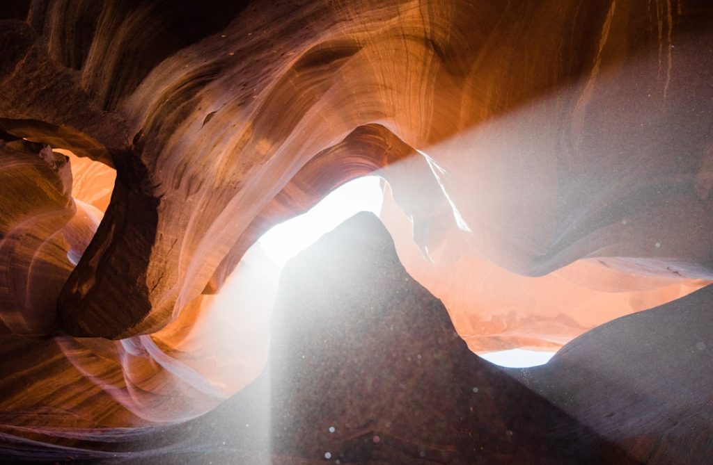
Exploring Antelope Canyon: Arizona’s Slot Canyon Majesty
Experience the otherworldly magic of Antelope Canyon, Arizona's most photographed slot canyon system. This extraordinary Antelope Canyon Arizona road trip takes you through narrow passages carved by water over millennia, where light beams dance through canyon walls in mesmerizing displays. Discover why this natural wonder has become a bucket-list destination for photographers and nature enthusiasts alike.
📖 About This Destination
❄️ Seasonal Tips
Spring 2026 offers ideal conditions with mild temperatures (60-75°F), minimal rainfall, and perfect sun angles for light beams in Antelope Canyon. Carry layers as mornings and evenings cool significantly. Sunscreen and hats are essential—the canyon walls reflect intense sunlight. Afternoon thunderstorms occasionally occur; check forecasts and avoid canyons during rain warnings. Roads are typically clear, though occasional wind can affect driving conditions. Reserve RV sites well in advance for popular spring season.
📍 Location
✨ What to See & Do

Upper Antelope Canyon Light Beams
Witness the world-famous ethereal light shafts that penetrate the narrow canyon opening above, creating breathtaking plays of golden and orange light against deep purple and burgundy rock walls. These celestial light beams are at their most dramatic during spring and early summer midday hours, transforming the narrow canyon into an otherworldly cathedral that has inspired millions of photographs.

Lower Antelope Canyon Corkscrew Formations
Navigate through dramatic S-curved passages and climbing ladders descending 93 feet into the belly of the earth. Lower Canyon features the famous 'Corkscrew' passage with its spiraling rock formations and towering narrow walls, offering a more adventurous experience than Upper Canyon with equally stunning scenery and fewer crowds.

Horseshoe Bend Colorado River View
Hike 1.5 miles to one of North America's most iconic viewpoints overlooking a dramatic 270-degree meander of the Colorado River. The surreal turquoise waters contrast brilliantly against rust-red canyon walls, and spring's comfortable weather makes this moderately challenging trail ideal for photography and panoramic viewing.

Lake Powell Water Adventures
Explore North America's second-largest reservoir with stunning turquoise waters surrounded by 1,960 miles of scenic shoreline. Spring boating conditions are ideal with comfortable temperatures, and boat tours access remote canyon walls and geological formations inaccessible by land, providing unique perspectives of the region's stunning geology.

Page Town and Navajo Culture
Immerse yourself in authentic Navajo culture by visiting Navajo Indian Village, watching traditional crafts demonstrations, and supporting Navajo-owned tour operators and businesses. The town serves as a cultural hub for the region, offering opportunities to learn about indigenous history, geology, and the sacred significance of these slot canyons to the Navajo Nation.
🍽️ Where to Eat
Discover fantastic dining options in the area.
🍽️ Ken's Old West Restaurant, American
🍽️ Strombolli's Italian Restaurant, Italian
🍽️ Bonkers Restaurant, American
🍽️ Zapata's Mexican Restaurant, Mexican
🍽️ Fiesta Mexicana, Mexican
❓ Frequently Asked Questions
What is the best time to visit Antelope Canyon for light beams?
The most spectacular light beams occur from April through September, with peak displays between 10 AM and 3 PM. Spring months offer ideal lighting angles combined with comfortable temperatures, making them excellent for your Antelope Canyon Arizona road trip without summer's intense heat.
Can I visit both Upper and Lower Antelope Canyon in one day?
Yes, most visitors combine both canyons in a single day. Each tour lasts 1.5-2 hours, plus travel time between locations (10 miles, 20 minutes). Plan 4-5 hours total to comfortably experience both sites with tour transitions and a meal break.
Are there RV hookups near Antelope Canyon?
Yes, Page has several RV parks with full hookups including Wahweap Campground (Glen Canyon NRA), Page-Lake Powell Campground, and private facilities. Most accommodate large rigs, though advance reservations are essential during spring and summer peak season.
Is Antelope Canyon safe during flash flood season?
Slot canyons are dangerous during rain due to flash flood risk. Tours operate based on weather conditions, and visits are cancelled during rainstorms or high runoff. Always check current conditions and follow ranger advisories before entering the canyon.
Do I need a guide to visit Antelope Canyon?
Yes, guided tours are mandatory for both Upper and Lower Antelope Canyon. Tours are operated by Navajo-owned businesses, provide historical and geological context, and ensure visitor safety while respecting sacred tribal lands.
🌟 Most Beautiful Route of the Month
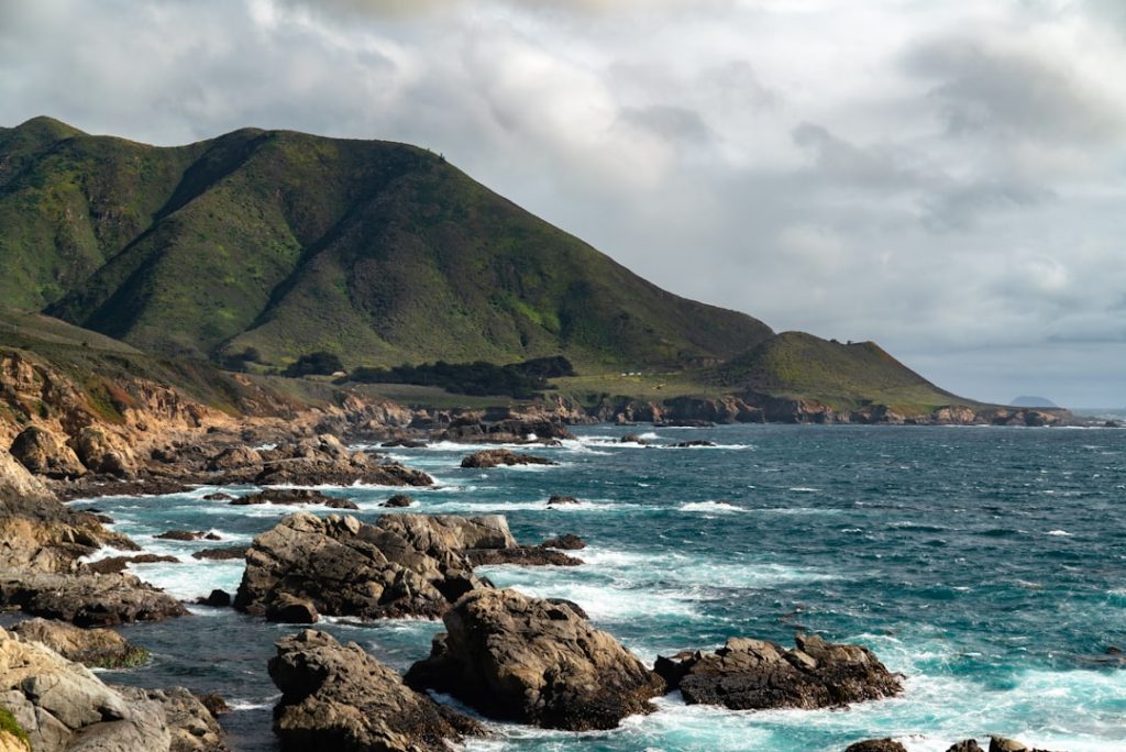
Big Sur Coastal Escape: California’s Most Dramatic Cliffside Drive
**Engineering Marvel Through Pristine Wilderness** Construction of Highway 1 through Big Sur took 18 years to complete, with workers carving this engineering masterpiece through nearly impenetrable terrain between 1919 and 1937. The road itself becomes a destination, featuring dozens of dramatic hairpin turns, including the famous Bixby Creek Bridge at mile marker 42, an iconic 260-foot span that appears to hover above a misty gorge. Modern travelers experience the same sense of wonder as early explorers, navigating curves that reveal new panoramas around nearly every bend of this spectacular Big Sur coastal route.
**Pristine Beaches and Hidden Coves** Along this 90-mile stretch, countless pullouts and parking areas provide access to some of California's most secluded beaches and tide pools. Julia Pfeiffer Burns State Park, located at mile marker 56, showcases the famous McWay Falls—a pristine 80-foot waterfall cascading directly onto a crescent-shaped sandy beach framed by towering cliffs. Pfeiffer Beach, known for its rare purple sand caused by manganese garnet deposits, lies just south of the falls and offers one of the most unique coastal experiences in the western United States. Cone Peak, visible from many viewpoints along the route, rises 5,155 feet within just 3 miles of the ocean—a dramatic elevation change that exemplifies Big Sur's vertical landscape.
****Wildlife and Natural Wonders** The Big Sur region protects critical habitat for California's diverse coastal wildlife, including gray whales during their spring migration northward, sea otters inhabiting rocky kelp forests, and endangered California condors soaring above the ridgelines. Elk herds roam the inland valleys, and Pacific gray seals bask on offshore rocks visible from numerous scenic overlooks. The pristine marine environment supports rich kelp forests that can be observed from coastal viewpoints, particularly during spring when water clarity improves and marine life activity peaks.
****Practical Driving Considerations** The Big Sur scenic drive demands focused attention, with sections featuring no guardrails, narrow shoulders, and sudden curves requiring speeds between 10-25 mph on the most dramatic sections. Spring weather is generally stable, though morning fog frequently shrouds the coast until mid-morning, and occasional afternoon winds can impact high-profile vehicles. The route contains limited services between Carmel and San Simeon—a crucial 90-mile stretch—so travelers should fuel up before departure and pack supplies. Cell phone service is spotty throughout the region, making traditional maps and navigation tools essential.
****Optimal Stop Points and Viewpoints** Point Lobos State Natural Reserve, just south of Carmel at mile marker 0, offers cypress groves, rocky coves, and spectacular ocean vistas within a manageable 4-mile scenic loop accessible from Highway 1. Nepenthe restaurant, perched 808 feet above the ocean at mile marker 29, provides both dining and panoramic viewing opportunities across the Santa Lucia Mountains meeting the Pacific. Pfeiffer Beach and McWay Falls State Park require short hikes (15-45 minutes) leading to unforgettable coastal perspectives. The entire Big Sur coastal scenic drive typically requires 4-5 hours of actual driving time, though most travelers allocate 2-3 days to properly experience the numerous stops and attractions.
****Spring Seasonal Magic** April and May represent ideal months for this Big Sur coastal drive, when gray whale migrations reach their northern peak, wildflowers paint hillsides in vivid purples and golds, and water temperatures hover around 52-55 degrees Fahrenheit. Springtime weather provides the clearest skies and most stable conditions of the year, though travelers should prepare for rapid weather changes and bring layers. The combination of migrating marine mammals, blooming vegetation, and optimal driving conditions makes spring the premier season for experiencing this unmatched California coastal journey.
🛣️ Major Stops

Point Lobos State Natural Reserve, California

Bixby Creek Bridge, California

Pfeiffer Beach and McWay Falls State Park, California

Nepenthe Restaurant Overlook, California
🎯 Attractions
🎯 McWay Falls Waterfall
An 80-foot waterfall cascading directly onto a pristine crescent-shaped sandy beach, framed by towering sea cliffs and accessible via a scenic 45-minute roundtrip hiking trail through coastal redwood groves.
🎯 Point Lobos State Natural Reserve
A rugged coastal preserve featuring windswept Monterey cypress groves, rocky inlets, abundant tide pools, and opportunities to spot sea otters, harbor seals, and migrating gray whales from elevated coastal trails.
🎯 Bixby Creek Bridge
An architectural marvel completed in 1932, this 260-foot reinforced concrete arch bridge spans a dramatic coastal gorge and ranks among California's most photographed structures, with multiple pullout viewing areas.
🎯 Julia Pfeiffer Burns State Park
A 3,580-acre coastal wilderness park encompassing dramatic sea cliffs, secluded beaches, lush redwood canyons, and multiple hiking trails ranging from 15-minute walks to full-day expeditions.
🎯 Pfeiffer Beach (Purple Sand Beach)
A unique coastal beach renowned for its rare purple-hued sand caused by manganese garnet mineral deposits, offering distinctive photography opportunities and excellent tide pool exploration.
🎯 Big Sur River
A pristine coastal river system that carves through the Santa Lucia Mountains, creating scenic overlooks and recreation areas throughout the Big Sur region's inland valleys.
❓ Frequently Asked Questions
Is Big Sur safe to drive in spring, and what are the road conditions like?
Spring offers excellent driving conditions on Big Sur's Highway 1, with stable weather and clear visibility most days. Mornings may bring fog until mid-morning, and occasional afternoon winds can affect high-profile vehicles, but overall conditions are optimal. Road surfaces are well-maintained, though the route requires vigilant attention due to narrow shoulders, hairpin turns, and lack of guardrails on many sections.
How long does it take to drive Big Sur from Carmel to San Simeon?
The 90-mile drive typically requires 4-5 hours of actual driving time without stops. However, most travelers allocate 2-3 days to explore the numerous viewpoints, state parks, and attractions along the route. Planning a leisurely pace allows time for photography, hiking, and appreciating the dramatic scenery.
Are there gas stations and services along the Big Sur scenic route?
Services are extremely limited along the 90-mile stretch between Carmel and San Simeon. The nearest fuel and supplies are in Carmel at the route's start or San Simeon at the finish. Travelers should fuel up before departing and pack provisions, as the entire middle section contains minimal commercial services.
What wildlife can I expect to see during a spring Big Sur drive?
Spring brings gray whale migrations northward along the coast, making April-May prime viewing months from numerous overlooks. Sea otters inhabit rocky kelp forests visible from coastal viewpoints, and endangered California condors soar above the ridgelines. Elk herds roam inland valleys, and Pacific gray seals bask on offshore rocks during spring months.
Which viewpoints and stops are must-sees on the Big Sur coastal drive?
Point Lobos State Natural Reserve near Carmel offers cypress groves and rocky coves; McWay Falls at Pfeiffer Beach State Park features an 80-foot waterfall cascading onto a pristine beach; Nepenthe restaurant provides 808-foot elevation ocean views; and Bixby Creek Bridge is an iconic 260-foot architectural landmark spanning a dramatic gorge.