💡 Key Recommendation
Use truck-specific GPS and grade calculator apps to safely navigate mountain passes without getting stuck on roads too steep or narrow for your RV
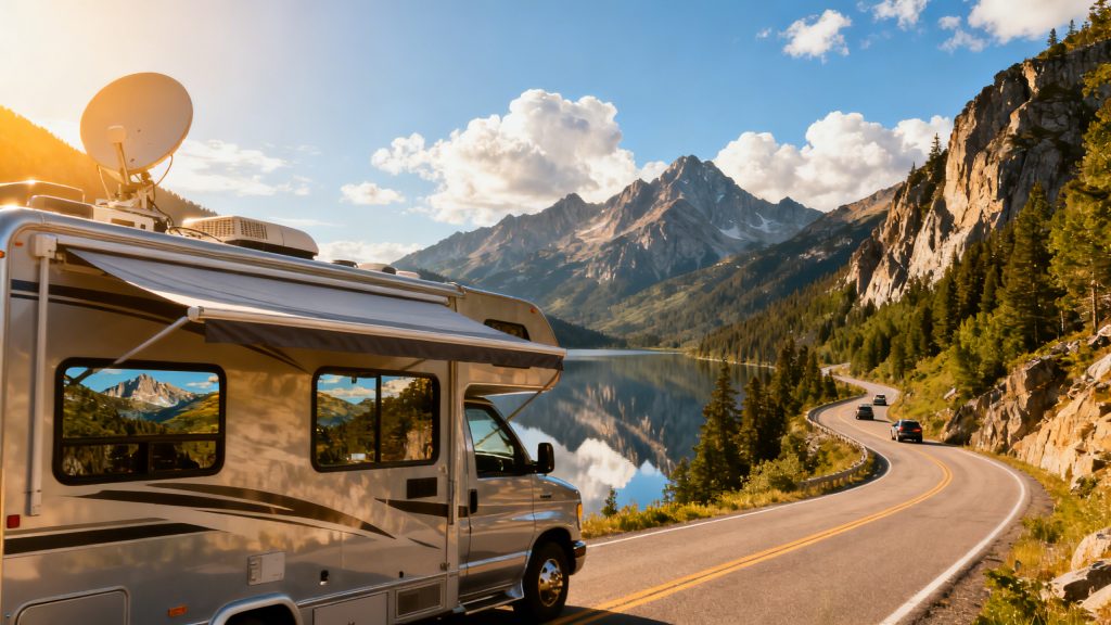
Why This Matters
Mountain passes present unique challenges for RV drivers that standard GPS navigation simply isn’t designed to handle. Regular car navigation systems routinely direct RVs onto steep grades, narrow roads, and low-clearance routes that can result in brake overheating, engine strain, or even getting physically stuck in areas where turning around is impossible. Using truck routes and grade calculators transforms mountain driving from a gamble into a calculated journey, ensuring your RV follows roads specifically designed to handle large, heavy vehicles.
The consequences of poor mountain route planning extend far beyond inconvenience – they can be financially devastating and physically dangerous. Emergency towing from remote mountain locations can cost thousands of dollars, while brake failure on steep descents poses serious safety risks. By leveraging truck routing systems and grade calculation tools, RV drivers gain access to the same route intelligence that professional truckers use daily, avoiding roads with excessive grades, weight restrictions, and clearance limitations that could turn a scenic mountain adventure into a costly nightmare.
📋 Industry Standards & Best Practices
The trucking industry generally considers grades exceeding 6% as challenging for heavy vehicles, with many commercial truck routes specifically designed to avoid sustained grades above 8%. Professional drivers use specialized GPS systems that factor in vehicle weight, length, and height restrictions, following designated truck routes that maintain manageable grade percentages through mountain terrain. RV drivers should adopt these same standards, treating their recreational vehicles with the same routing considerations as commercial trucks, since Class A motorhomes and large travel trailers face identical physical limitations when navigating steep mountain passes.
🎯 Product Recommendations
Invest in a dedicated truck GPS unit or commercial-grade navigation app that includes grade information, truck route designations, and real-time restriction updates for mountain passes
Calculate your RV’s power-to-weight ratio and cross-reference it with pass grade percentages to determine safe climbing speeds and identify potential trouble spots before departure
Always plan primary and alternate truck routes through mountain areas, checking current road conditions and seasonal restrictions on state DOT websites before traveling
Complete Guide
Start by switching to truck-specific GPS systems like Garmin dezl or apps like CoPilot Truck. These systems allow you to input your RV’s exact dimensions, weight, and specifications, then calculate routes that avoid low bridges, weight restrictions, and roads unsuitable for large vehicles. They maintain databases of truck-approved routes that have been tested by commercial drivers hauling similar-sized loads.
Complement your GPS with grade calculation apps like Mountain Directory or RV Trip Wizard’s elevation profiles. These tools show you the exact steepness and length of grades along your route, allowing you to prepare mentally and mechanically for challenging sections. A 6% grade for three miles requires different preparation than a 10% grade for half a mile – you need to know which you’re facing.
Before tackling any mountain pass, research alternate routes and identify bail-out points. Study your route on Google Earth’s satellite view to visualize road conditions, shoulder width, and terrain challenges. Look for truck stops or wide areas where you could safely pull over if conditions become challenging.
Time your mountain driving strategically. Start early in the day when you’re fresh and alert, avoiding afternoon thunderstorms that frequently develop in mountain regions. Plan for slower speeds – mountain driving typically cuts your normal travel speed in half, so adjust your daily mileage expectations accordingly.
Download offline maps before entering mountain areas where cell service becomes spotty. Nothing’s worse than losing GPS signal halfway through a challenging pass. Apps like Gaia GPS or even Google Maps’ offline feature can provide backup navigation when you need it most.
Connect with other RVers through forums like iRV2 or Mountain Directory’s community features to get real-time reports on current road conditions. Fellow RVers often share recent experiences with specific passes, including construction updates, weather impacts, or seasonal restrictions that might not appear on official sources.
Consider joining Good Sam or FMCA for their trip routing services, where experienced staff can help plan safe mountain routes based on your specific RV configuration. These services combine local knowledge with technical expertise to create routes that match your comfort level and vehicle capabilities.
By adopting professional truckers’ route-planning strategies, you’ll transform mountain travel from a source of stress into confident exploration of America’s most spectacular scenery.
Step-by-Step Instructions
Step 1
Input your RV’s exact dimensions (height, length, weight, axle count) into a truck-specific GPS system or app like Garmin dēzl or Rand McNally TND
Step 2
Use online grade calculators and mountain pass databases to identify all grades exceeding 6% on your planned route, noting both ascent and descent percentages
Step 3
Cross-reference your route with state DOT truck route maps and current road condition reports, marking any seasonal restrictions or construction delays
Step 4
Program both primary and backup truck routes into your navigation system, ensuring both options avoid car-only highways and maintain reasonable grade percentages for your RV’s capabilities
💰 Cost Analysis
Initial investment: $200-600 for professional truck GPS unit or $10-30/month for commercial navigation app subscriptions with truck routing features
Annual maintenance: $50-120 annually for GPS map updates and navigation app subscriptions to maintain current truck route and restriction data
5 year projection: $450-1,200 total over five years including initial equipment, annual updates, and subscription renewals for truck navigation services
Cost per year: $90-240 yearly average for maintaining access to current truck routing and mountain pass grade information
🌍 Regional Considerations
Western mountain states like Colorado and Montana provide detailed grade percentages and runaway truck ramp locations on their DOT websites, with specific truck route designations through major passes
Eastern mountain regions including the Appalachians often have more restrictive tunnel and bridge clearances, requiring careful height verification even on designated truck routes
Canadian mountain provinces enforce stricter chain requirements and seasonal restrictions on truck routes, with different grade calculation standards than US mountain passes
🌍Practical Applications
Eisenhower Tunnel on I-70 in Colorado requires checking current height restrictions (13’11”) and using truck-specific lanes, while the grade calculator shows 7% descents toward Denver requiring careful speed management
Donner Pass on I-80 in California features 6% grades and chain control areas where truck GPS systems provide advance warning and alternate routing during winter weather restrictions
Lookout Mountain on I-24 between Tennessee and Georgia shows 4-6% grades on truck route calculators, but car GPS might suggest steeper alternate routes that exceed RV capabilities
🔍 Common Misconceptions
Myth: Regular car GPS is adequate for RV mountain travel. Truth: Car navigation systems don’t account for vehicle restrictions, weight limits, or grade percentages that affect large RVs on mountain passes
False belief: All Interstate highways are safe for RVs in mountains. Reality: Many Interstate mountain sections have steep grades, low overpasses, or restrictions that require specific truck routing knowledge
Misconception: Grade calculators are only needed for steep mountain passes. Truth: Even moderate 4-5% grades can cause problems for underpowered RVs, making grade calculation essential for any mountainous terrain
📊 Comparison Analysis
🔧 Tools & Equipment
Truck-specific GPS unit (Garmin dēzl, Rand McNally TND) or smartphone with commercial navigation app (CoPilot Truck, Sygic Truck GPS Navigation)
Online grade calculator tools and state DOT websites for current mountain pass conditions, restrictions, and truck route designations
⏱️ Time & Cost Summary
Estimated Time: 2-3 hours initial setup to program RV specifications and learn truck routing features, plus 30-45 minutes additional route planning time for each mountain crossing to verify grades and restrictions
Estimated Cost: $200-600 for dedicated truck GPS or $10-50 annually for smartphone truck navigation apps, plus time investment for route planning and grade verification
📅 Maintenance Schedule
⚠️ Safety Considerations
FAQ
What are truck routes and why are they important for RV navigation through mountain passes?
How do grade calculators help determine if my RV can safely navigate a mountain pass?
What grade percentage is considered safe for most RVs traveling through mountain passes?
Which navigation apps and tools are best for finding truck routes through mountain passes for RVs?
How do I calculate the grade percentage of a mountain pass before traveling?
What information do I need about my RV to use truck routes and grade calculators effectively?
Are there specific truck route restrictions I should know about when taking my RV through mountain passes?
How do weather conditions affect truck route availability and grade calculations for mountain pass RV travel?
What are the most reliable sources for current truck route conditions through mountain passes?
How do I determine if a mountain pass has adequate truck stops and services along truck routes?
What should I do if my grade calculations show a mountain pass exceeds my RV’s capabilities?
How do truck route grade calculators account for loaded vs. unloaded RV weight when planning mountain passes?
What are the key differences between using GPS truck routing vs. manual grade calculations for mountain pass navigation?
How far in advance should I plan truck routes and calculate grades for mountain pass RV trips?
Can I rely on truck route designations alone, or do I still need to verify grades using calculators for RV mountain pass travel?
👨💼 Expert Insights
Professional truck drivers always plan alternate routes through mountains because weather and restrictions change rapidly – RV drivers should adopt this same redundant planning approach
Commercial drivers use the ‘safe speed rule’ on mountain grades: never exceed the speed where you can stop within half your sight distance, regardless of what grade calculators suggest is possible
Experienced RV owners recommend treating your motorhome or trailer like a 40-foot truck when route planning – if commercial trucks can’t use a road safely, neither should large RVs
📚 Related Topics
- RV brake maintenance and engine cooling system preparation for mountain driving
- Understanding RV weight distribution and power-to-weight ratios for grade climbing
- Winter mountain driving techniques and chain installation for RVs